Showing posts with label pembroke MA. Show all posts

Wednesday, March 20, 2019

Project Dale and Pembroke’s Tucker Preserve


Lately I’ve become fascinated with a certain stretch of the Indian Head River. From the bridge on Cross and State Streets, at the Hanover-Hanson town line, to Luddam’s Ford Park in Hanover and Pembroke, the river flows for two miles through a peaceful, secluded valley. On the Hanover side, a wide, mostly-flat woodland trail traces the route of the historic Hanover Branch railroad, passing behind private homes as it follows the course of the river. On the Hanson and Pembroke side, a network of cart paths and narrow trails provides access to both the forested upland and the water’s edge. It takes about two hours to walk the complete circuit.

Within this stretch lies an area once known as Project Dale. In Barry’s 1853 Historical Sketch of the Town of Hanover, it is described as, “very pleasant, . . .  surrounded by hills, clothed with evergreen, and deciduous trees.” A dale is a valley – usually a broad, open one. Today, this part of the Indian Head is no longer broad nor open, but it remains a valley . . . a geographic feature that’s relatively rare in our watershed. 

But what – you might ask -- is does the word “Project” signify? It’s hard to imagine, since now it’s so serene, but just 150 years ago this was a booming center of industry. “Project” likely refers to enterprise – specifically the tack factory that stood here. Between the tack factory, the railroad, the nearby anchor forge and additional factories, this was a busy place.

(from Briggs' History of Shipbuilding on North River)
Back in those days, the water level in the river was significantly higher and wider. Not for any natural reason – but because of dams. There was a dam at the tack factory, and when you walk along the water’s edge on the Hanson side of the river, you can easily discern where the water used to flow. 


There was – and still is – a dam at Luddam’s Ford too. While dams may fuel industries, they also prevent migratory fish from reaching their spawning grounds. These days, with the factories on our rivers long since gone, many communities are opting to remove obsolete dams and restore fish passage. 

Project Dale is a captivating spot. One of the best ways to access it is through the Tucker Preserve, a property owned by the Wildlands Trust. I recommend starting from the Pembroke side of Luddam’s Ford Park on West Elm Street, where you’ll find a large parking lot. Look upstream across the pondside meadow, and you’ll see a kiosk with a trail heading into the woods. 


For now, pay no attention to the colorful graffiti-covered ruins on the wooded side of the trail. We’ll get back to those later. Instead, keep your eyes on the river. Follow the path along the water’s edge. Soon a wooden bridge leads you across a brook, and then the trail begins a moderate incline. 


There is a wider, flatter option to the left, but the narrow trail to the right offers the best view. This is the Indian Head River, appearing more like a pond here because of the dam downstream. 


The trail continues through the woods to a second stream crossing, and this time you’ll have to make your way across flat rocks to reach the other side. Some days, it’s easy. Other days, when more water is flowing, the crossing requires precise footwork. 
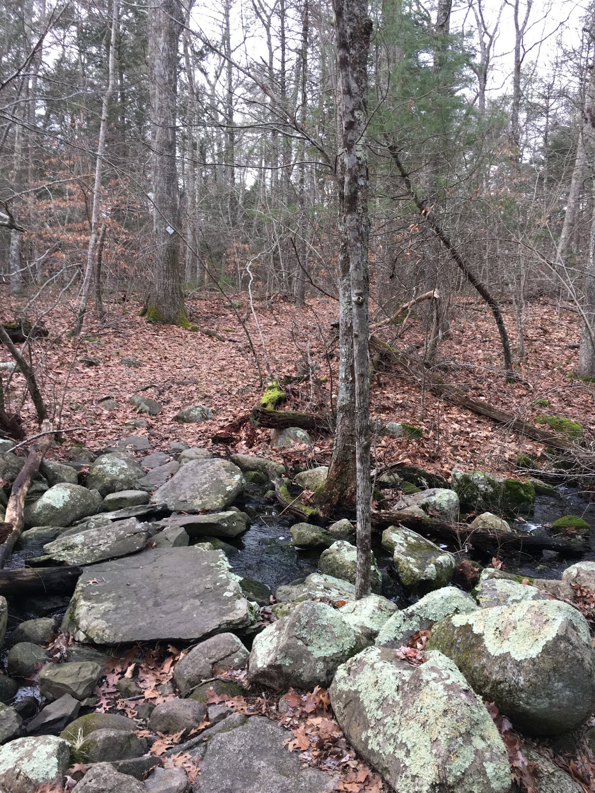

 At this point you will have entered a hemlock grove. If you look toward the river, you’ll find that you’ve climbed to the top of a ridge. Very likely you’ll spy a building in the distance. Continue along the trail, deeper into the woods. As the trail veers closer to the edge of the ridge, look down again. The valley is much narrower here, and incredibly picturesque. You are now at Project Dale. The building across the river was once the Waterman Tack Factory. 


 Beginning in the 1700s, this site was home to a number of industries. The earliest was probably a carding mill, where wool fibers were prepared for spinning. Other incarnations included a fulling mill (to clean and thicken wool fiber), and later a grist mill. In 1830, a tack factory moved in. Several owners later, it became the domain of L. C. Waterman & Co. In 1860, with 12 machines in operation, it employed 8-10 people and produced to 50-60 tons of tacks per year. Waterman tacks were used primarily in shoes, but also in the furniture and upholstery trades, and for laying carpet. Historians indicate that many shoe repair shops, even in New York and Philadelphia, would only use Waterman tacks. The business continued to expand and thrive, and by 1875 it employed 25 people and produced 250 tons of tacks per year.

I love this spot for its beauty, but even more because of how it illustrates the passage of time. Looking down from the ridge, you can see scattered remains of a concrete dam along the water’s edge.Scanning the course of the river, you might imagine how the power of the water behind the dam was harnessed to fuel the factory. You can probably guess where the water went in, and where it went out. But now, 150 years later, where has it all gone?


In February 1886 there was an unusually heavy rain – what historians refer to as a “freshet.” The water rose at such speed, and to such height, that it severely damaged not only the factory but the adjacent train tracks. The railroad was repaired, but ceased operations in the 1930s. Subsequent storms in 1938 and 1954 did permanent damage to industries throughout the river valley. Since then, Project Dale has become a different world. It’s so quiet now – and so natural -- it’s hard to imagine it was ever any other way.


The trail continues a short distance from the factory overlook and soon reaches the Tucker Preserve’s western boundary. 


Turn back here, and retrace your route until you reach the brook you crossed on foot. This time, proceed to your right and follow a loop trail through the southern half of the 78-acre property. (I recommend carrying a map). This will eventually bring you back to the wooden bridge and Luddam’s Ford.

As you approach the end of the trail, you will once again notice brightly-graffiti’d ruins in the woods off to your right. 


These are remains of the E. H. Clapp Rubber Works, which stood on both sides of the river at the turn of the 20thcentury. Norwell native Eugene Clapp began his enterprise in Hanover in 1873, using water power to grind and process rubber. By 1879 he was using steam power, and soon expanded into multiple buildings on both the northern and southern banks. 


A decade later, according to Briggs’ History of Shipbuilding on North River, he was “doing two or three times as much work as any of his competitors, and (was) handling more than one half of this business in the United States.”

from Briggs' History of Shipbuilding on North River


Thanks to the Wildlands Trust, the Tucker Preserve has been open to the public since 1993. It’s a special place -- not only rich in history, but populated by unusual (for this region) vegetation and wildlife. It is open daily from dawn to dusk. 

by Kezia Bacon
March 2019

Kezia Bacon's articles appear courtesy of the North and South Rivers Watershed Association, a local non-profit organization devoted to protecting our waters. For membership information and a copy of their latest newsletter, contact NSRWA at (781) 659-8168 or visit www.nsrwa.org. To browse 20 years of nature columns, visit http://keziabaconbernstein.blogspot.com

Thursday, October 11, 2018

Should We Ban Plastic Bags? (updated)


Have you heard about the colossal gyres of plastic trash in our oceans? The Great Pacific Garbage Patch, off the coast of California, is estimated to be 1-2 times the size of Texas! To date, we have not found an effective way to eradicate these monstrosities. Which unfortunately means that sea animals are dying in great numbers – about 100,000dolphins, seals, turtles, porpoises and whales per year – plus another 2 million birds – all from ingesting, or becoming entangled in, single-use plastic bags.

This sort of news makes me think twice about the disposable plastic products I use regularly – things like sandwich bags, drinking straws, and food wrap. There has to be a better way.

So let’s talk about the ubiquitous single use plastic shopping bag. Even those of us who bring our own bags to the store sometimes forget, and end up carrying our purchases home in plastic. I generally repurpose those flimsy bags for trash disposal. But even when I’ve doubled the life of a single-use bag, it still ends up in the garbage, contributing to the ongoing global problem.

One way to address this issue is at its source: to ban the use of single-use plastic bags, like they’ve done in Europe, China, and California, as well as cities like New York, Los Angeles, DC, Boston and Chicago, . . . and small towns too. Right here in Massachusetts, there are 83municipalities with restrictions on plastic bags, including Plymouth, Duxbury, and Marshfield. Pembroke and Scituate will consider town-wide bans of single use plastic bags at their Town Meetings this fall.

When I first began reading about these bans, I shrugged. How could they succeed? People are reluctant to give up their conveniences, and getting into the habit of always having a shopping bag with you is a lifestyle shift. But after delving a little deeper into the research, I now see how effective such bans can be. Here’s what I learned.

How Many Bags?
Every year, Americans discard 100 billion single use plastic bags. In Massachusetts, that’s about 51,000 plastic bags per week for the average market. These bags are our third largest source of litter, behind cigarette butts and bottle caps. 

Where Do They Go Next?
What happens to these bags when we’ve discarded them? They don’t just disappear. Plastic can be recycled, but it doesn’t biodegrade. Instead, over time, it breaks down into increasingly smaller fragments, eventually into microplastics that can do grievous harm to animals, the oceans, and our environment in general. 

Why Are Plastic Bags A Problem?
• From the start, single use plastic bags cause trouble. The oil or gas required to produce them, and the greenhouses gases released during production, simply do not justify their very short period of use. We’re depleting non-renewable resources in order to make bags that continue to do harm in their afterlife.

• Many communities are unable to recycle them, due to repeated issues with machinery jams. In the past, we could send our recycling materials to China, but not anymore.

• It takes 200+ years for a plastic bag deposited in a landfill to decompose. During this time it releases methane gas and carbon dioxide. If incinerated, it releases, toxic fine particles into the air.

• In the oceans, where many of these bags ultimately end up, tiny fragments of plastic are consumed inadvertently by fish and other sea animals. These toxins move up the food chain, eventually appearing -- imperceptibly -- in the fish we eat.

What Kinds of Bags Get Banned?
Plastic shopping bag bans are becoming increasingly popular because they significantly decrease waste while encouraging the use of more sustainable (often cloth) shopping bags. These bans don’t prohibit heavier plastic bags, nor the ones used for meat or produce, newspapers or dry cleaning. The only bags banned are the thin plastic disposable type most commonly found at grocery store checkouts. 

How Can I Help?
Scituate resident Kate Glennon, who has helped bring a plastic bag ban to the town’s upcoming own Meeting Warrant, puts this all in perspective. She writes, "Now more than ever, we are seeing how small local choices, personal choices, can effect change on a larger scale. That's how we started polluting, and that's how we can abate the damage we've done. Changing our consumer habits to become less dependent on conveniences like single-use plastics creates a ripple effect visible to manufacturers and retailers, and visible in shorelines and waterways—not just in Scituate but all our interconnected communities." Scituate’s Town Meeting takes place November 14th. If you’re a Scituate resident, please vote to support the ban of single use plastic bags.

Pembroke residents have a similar opportunity, taking place at Town Meeting on October 23rd. In support of the ban, resident Stephanie Hagan writes, “Although a plastic bag ban could be an inconvenience to some, the economic and environmental inconveniences are greater. I believe most consumers are unaware they’re paying 4 cents a bag, built into their commodities. At 9 million bags a year in Pembroke alone, that’s over $350,000 and about $30 a year per family. . . The mere inconvenience of bringing your reusable bag or choosing paper does not outweigh the importance of this issue.”

Glennon adds, "I'm not sure anyone will miss the thin plastic grocery bags. They're flimsy and we know they end up in the landfill by the millions, and in waterways. There's no shortage of other thin plastic bags (like bread bags) that can be kept for household re-use."

If you live in a town that does not presently ban these bags, you can still choose not to use them personally. You might also advocate for a ban in your own town. 

by Kezia Bacon 
October 2018

Kezia Bacon's articles appear courtesy of the North and South Rivers Watershed Association, a local non-profit organization devoted to protecting our waters. For membership information and a copy of their latest newsletter, contact NSRWA at (781) 659-8168 or visit www.nsrwa.org. To browse 20 years of nature columns, visit http://keziabaconbernstein.blogspot.com

Thursday, September 20, 2018

Noteworthy North River Ships

The Beaver, one of the ships involved in the Boston Tea Party, was built on the North River.
The North River today is so serene: it can be difficult to imagine that it was once a booming center of industry. Beginning in the mid-1600s and continuing long into the 19thcentury, this 12-mile waterway was home to a total of 24 shipyards. Between 1645 and 1871, more than 1,000 vessels were constructed along the river in Hanover, Pembroke, Marshfield, Norwell and Scituate. 

The shipbuilding industry provided jobs for all sorts of craftsmen – carpenters, caulkers, liners, sailmakers, and so on, -- as well as sawmill operators to provide lumber, and pilots to maneuver the ships downstream to the ocean – a complicated process that often took a full week. Vessels were commissioned by such entities as the US Navy, British trade companies, and whaling fleets from Nantucket, New Bedford and Martha’s Vineyard. 

If you’re interested in the histories of the North River shipyards and the vessels constructed there, check out L. Vernon Briggs’ book, History of Shipbuilding on the North River, which is available in most of our local libraries. In the meantime, I’ve compiled some basic facts about some of the more famous ships.

The Beaver: One of the ships involved in the Boston Tea Party (December 16, 1773) was The Beaver, a whaler constructed by Ichabod Thomas at the Brick Kiln Shipyard in Pembroke. Commissioned by the prominent Rotch family of Nantucket, it measured 85 feet in length, with an almost 24 foot beam, and a draft of only nine feet, to accommodate Nantucket’s shallow harbor. Captained by Hezekiah Coffin, the Beaver made its maiden voyage from Nantucket to London to deliver whale oil. As was customary, it took on a different cargo for its return, in this case some fine English furniture as well as 112 chests of tea from the British East India Company. After spending two weeks in quarantine in Boston Harbor, due to a case of smallpox on board, it finally docked at Griffin’s Wharf on December 15, 1773. The next day, The Sons of Liberty, a group of more than 100 men from all walks of life, led by Samuel Adams, boarded the Beaver, as well as two other ships loaded with tea -- the Dartmouth and The Eleanor. Being careful not to damage the ships, they smashed open 340 chests of tea (approximately 92,000 lbs.) and dropped them into the harbor, a significant act of protest in what would become the American Revolution. The Beaver returned to the whaling industry but was sold shortly thereafter.

Further reading:Defiance of the Patriots: The Boston Tea Party & the Making of America by Benjamin Carp

The Columbia: It is possible that the first American ship to circumnavigate the globe was constructed on the North River. Some say the ship was actually built in Plymouth, but that its keel was constructed here. But local history claims that James Briggs constructed the three- masted ship at Hobart’s Landing in Norwell in 1773. It was 83 feet long, with a 24-foot beam and an 11-foot draft. Owned by John Kendrick or Joseph Barrell, its captain was Robert Gray. Gray was active in the gold and silver trade with China. However when he found that European traders were consistently outbidding him, he began instead to purchase fur in the Pacific Northwest. In 1792, he observed the Columbia River near what is now Portland, Oregon, and named it after his ship. The Columbia River became a major venue for the fur trade. The ship itself was decommissioned for salvage in 1806.

Further reading: Columbia’s River: The Voyages of Robert Gray by J. Richard Nokes

The Essex– Another disputed North River vessel was whaleship Essex. Local records indicate that it was built in 1796 on the North River, with no exact location provided. However the town of Amesbury on the North Shore makes a similar claim. The ship – which was 87 feet long, with a 24-foot beam and 12-foot draft -- was launched in 1799; in 1804, Nantucket merchants purchased it in Salem. In August 1819, George Pollard Jr. was its commander when it departed Nantucket for the South Pacific. On November 20thof that same year, the captain spotted a school of whales and set off in pursuit. A large sperm whale struck the ship forcefully with its head, knocking those on board off their feet. Soon after the same whale struck again, this time completely staving in the ship’s bow. The 20-man crew quickly gathered equipment, food and water, and disembarked to 3 smaller boats, then watched while the Essex sank. What followed was an ordeal that included dehydration, starvation, taking refuge on a small tropical island, and eventually cannibalism. Two men survived. If this sounds familiar, it might be because it served as the inspiration for Herman Melville’s Moby-Dick. 

Further reading: In The Heart of the Sea by Nathaniel Philbrick

The Globe– A local ship with an equally remarkable story, The Globe was constructed at Wanton Shipyard in Norwell in 1815. With two decks and three masts, the ship measured 94 feet in length, with a beam of 26 feet. A successful whaler, it is renowned as being the first ship to bring 2000 barrels of sperm oil into the United States. But The Globe is best known for a gruesome mutiny in 1824. The ship was owned by C. Mitchell & Co., and commanded by Thomas Worth. After sailing from Nantucket on December 20, 1822, it arrived in the Sandwich Islands in the South Pacific on May 1, 1823, then continued to Hawaii and Japan. By then, six of the 21-man crew had deserted. The Globe continued south toward Fanning Island. In January 1824 ,after an incident during which a crewman was whipped as punishment, crewmen Samuel Comstock and Silas Payne murdered the captain as well as the first and second mates, then threw their bodies overboard. Not daring to go to port for fear of repercussions, they ran the ship aground on Mili Atoll, with a plan to take the provisions, strip the ship, and burn it, and then take up residence on the island. But there was more trouble to come. Comstock was killed by his shipmates. Crewman Gilbert Smith took charge of the ship and escaped by night with five other men, leaving the others behind. When The Globe arrived at Valparaiso, Chile, in June, the American Consul took possession of it, and sent it back to Nantucket. Most of the men remaining on Mili Atoll were killed by the natives, but two survived and were rescued after 22 months. The ship was sold for salvage in 1828.

Further reading:Demon of the Waters by Gregory Gibson.

by Kezia Bacon
September 2018 

Kezia Bacon's articles appear courtesy of the North and South Rivers Watershed Association, a local non-profit organization devoted to protecting our waters. For membership information and a copy of their latest newsletter, contact NSRWA at (781) 659-8168 or visit www.nsrwa.org. To browse 22+ years of nature columns, visit http://keziabaconbernstein.blogspot.com

A view of the Brick Kiln Shipyard in Pembroke.


Wednesday, September 6, 2017

A Pontoon Boat Cruise on the North River

Looking downstream from the bow of the pontoon boat.
-->
If you’re reading this article, you are probably aware of the North and South Rivers -- two beautiful, healthy, tidal waterways whose watershed comprises much of the South Shore. Chances are, you’ve also spent some time there – perhaps by boat, or with a canoe, kayak or paddle board, or by walking in one of the numerous conservation areas that border them.

On the other hand, maybe you haven’t. Whether paddling trips and hikes aren’t your thing, or you have other reasons for not being able to access the rivers, I have good news to share with you. There’s another option! The North and South Rivers Watershed Association (NSRWA) now offers Pontoon Boat Cruises.

A pontoon boat is a motorized boat with a wide, flat deck, and plenty of room for upright seating. The deck is supported by two or three metal tubes (or pontoons), which provide flotation. While not the most aerodynamic, a pontoon boat moves quickly and deftly enough to provide a smooth, steady ride. The NSRWA’s boat – donated by a Marshfield family -- has comfortable bench seats in both the sun and the shade, all with a terrific view. Plus there’s no climbing – from the dock, you walk straight on and off the vessel. This is a very different experience from a kayak or a canoe.

Throughout the boating season (late spring til mid-autumn) NSRWA offers pontoon boat cruises several times per month. Each includes a licensed boat captain and a tour guide. You can choose the “Nature and History” themed cruise or just “Nature.” “Fall Foliage” and “River Wildlife” are other options. You can also charter your own.

In August, I signed up for one of the Nature and History-themed cruises. After registering online, I received my instructions, so I knew exactly where to park and what to bring. At 10:00am, I met my captain, guide, and fellow participants at Roht Marine, on the North River, on the Marshfield-Scituate line (Route 3A). After a brief safety overview, we were off.
I already knew a fair amount about the history of the North and South Rivers, but on the tour, I learned quite a bit more! Our guide explained how our region has changed since the last ice age – and how the rivers were formed. He discussed the first European settlers in our area and the ways in which they interacted with the native tribes who had been here for years. He explained salt marsh haying, and packet ships, and gave an overview of the local shipbuilding industry. He also discussed the ecology of the salt marsh, and pointed out some of the wildlife that make their home there. We saw marsh wrens, red tail hawks and osprey, and kept an eye out for bald eagles (they nest nearby.) There were maps and other visual aids to enhance the presentation, plus we were encouraged to “Ask anything.”

After an hour moving steadily upstream through gorgeous landscapes, we reached the Route 3 Bridge in Pembroke. The captain turned the boat around, and for most of our journey back to the starting point, we were encouraged to admire the view. This led to casual conversations among the participants and plenty more insights from the guide.

The 2-hour tour was extremely enjoyable. Time passed quickly. I found myself wanting to return, soon, with various friends and family members, especially those who aren’t inclined to experience the rivers in other ways. A Pontoon Boat Cruise would be a lovely way to mark a special occasion – a birthday or anniversary, for example, or a retirement. At $50 per person (for NSRWA members, $75 for non-members) it’s a bit of an investment, but well worth the cost.

If you’re interested in joining a Pontoon Boat Cruise, there are a number of them coming up this fall – nearly every weekend through the end of October. Most go upriver through Marshfield and Norwell, but some go downstream to The Spit. Visit nsrwa.org for details and to register.

by Kezia Bacon
August 2017


Kezia Bacon's articles appear courtesy of the North and South Rivers Watershed Association, a local non-profit organization devoted to protecting our waters. For membership information and a copy of their latest newsletter, contact NSRWA at (781) 659-8168 or visit www.nsrwa.org. To browse 20 years of nature columns, visit http://keziabaconbernstein.blogspot.com

A view from the stern of the pontoon boat.

Friday, May 2, 2014

Lost in the Woods

-->
A view of the Indian Head River from the Hanover side.
 We had been walking in the forest for more than an hour. We were still on a trail, but it did not seem to be headed in the right direction . . . or in any particular direction. A few times we’d had to retrace our steps: either the trail would end in a No Trespassing sign, or in someone’s back yard, or it would disappear entirely. We were lost in the woods.

Not that we were entirely lost! We had followed a very clear path up one side of the Indian Head River in Hanover. We had crossed the river at State Street in Hanson, and followed a trail back into the woods in Pembroke, with the intention of finding our way into the Wildlands Trusts’s Tucker Preserve, which wasn’t all that far downstream. But we never found it. So we sort-of knew where we were, but not really.

This was a familiar predicament. I’d walked the inviting, scenic trails along the Indian Head River before. At least once, I’d found my way back to the parking area on West Elm Street, via the 78-acre Tucker Preserve. But once or maybe twice before, I’d been similarly lost: on a trail, but not the right trail.

The landmarks were familiar – I’d been there before. But I couldn’t be sure if they were the right kind of familiar. Just because we recognize something doesn’t mean it’s what we’re looking for.

I went away recently for a long weekend: a yoga retreat at Kripalu, in the Berkshires. I spent my afternoons on the hiking trails in the mountains behind the retreat center. I’d been given a map when I arrived. It included not only the mileage of various trails, but also the level of difficulty and an estimation of the time required to complete each hike. Map in pocket, I was far from lost.


Looking out on Monks Pond.
 The first day, I chose the trail to Monks Pond. It was a steady uphill climb, and rather muddy. I really had to pay attention, so I wouldn’t slip. One of my objectives for my time away was to gain some perspective. What would I like to achieve, going forward, and what would I need to change, in order to get there? The muddy uphill path seemed like an apt metaphor. I tend to choose the more challenging routes. I make things harder for myself than they need to be. And thus over time, certain kinds of suffering become familiar. It’s like being on that trail that leads to nowhere: it’s not the right trail, but it’s familiar, so it takes me a while to figure out that I need to find a different route.

Standing in a stream, attempting to clean the mud off my boots.
Back to the Indian Head River. So we were lost in the woods. We had at least two options. One was to attempt to retrace our steps, and hope to find the trail we’d missed before. At worst, we could cross the river again at State Street and go back the way we came. Another option was to consult our smart phones. I’d been meaning to download a trail GPS app, but I hadn’t yet. However I did have several, more general, street mapping apps. Quickly we determined that while we were nowhere near the Tucker Preserve, we were quite close to houses and roads. We chose a back yard and very quickly passed through it, to the street. It wasn’t quite so pleasant, walking at the roadside instead of in the forest, but at least we knew where we were going. And twenty minutes later, we were back to our cars. I have since downloaded a map.

On the South Shore, we can get lost in the woods, but how lost are we really? We don’t have any wilderness here. Even our largest conservation parcels aren’t all that big. We follow a trail, and even if we lose your way, we eventually come upon  a house or a road. As soon as we find civilization, we can find our way back home.

I’ll be heading back to the Indian Head River soon. Now that I’ve been lost there at least twice, I am determined to get my bearings and learn the layout of the intersecting conservation properties that line its banks. Next time I’ll start on the Pembroke side, though, and walk from the fish ladder, into the woods where I know there’s a plainly-marked trailhead for the Tucker Preserve. Also next time, I’ll be sure to bring my map.

 by Kezia Bacon
April 2014

Kezia Bacon's articles appear courtesy of the North and South Rivers Watershed Association, a local non-profit organization devoted to the preservation, restoration, maintenance and conservation of the North and South Rivers and their watershed. For membership information and a copy of their latest newsletter, contact NSRWA at (781) 659-8168 or visit www.nsrwa.org. To browse 15 years of Nature (Human and Otherwise) columns, visit http://keziabaconbernstein.blogspot.com

Tuesday, August 27, 2013

Boys in the Woods

-->
The Teeple, Morey, Beal and Bernstein children prepare for a walk at Willow Brook Farm Preserve in Pembroke.

Anyone who reads this column regularly knows that I enjoy a good walk in the woods. Dedicated readers also know that I have a son, Abel, who is now seven years old. I’ve been taking Abel for nature walks since he was an infant – first in a Baby Bjorn carrier, then in a jog stroller, and later with him walking along beside me. He really enjoyed these outings when he was little. Now, not so much. “It’s boring, Mom.”

But last spring I figured out a way to make it less boring. Invite friends. Not just one or two, but a whole pack of them. Boys plus woods equals fun! So this summer I planned a few group nature walks, inviting some of Abel’s friends and their families to join us at some of the more child-friendly local conservation properties. And I was delighted to see that it worked. The boys had fun . . . and the adults enjoyed themselves as well.

Our first exploration was at the Norris Reservation on Dover Street in Norwell, which is managed by The Trustees of Reservations. I’d picked up this year’s South Shore Quests booklet, so we followed the route suggested there, looking for clues that would ultimately reveal where the Quests box was hidden (an opportunity for us to sign a guest book and stamp our Quest passport). The clues gave us a compelling reason to carry on, despite some wet weather, but I’m not sure we even needed the incentive. The boys were quite happy to be scampering up and down the trails, finding and carrying big sticks, and looking for snakes and frogs – they found plenty of the latter. I didn’t bother to try to teach them anything about the land we were exploring – except when they asked, and they had some good questions – but instead I just let them absorb the forest environment, and enjoy themselves. And they did.

Our second trip followed another South Shore Quest, this time at Willow Brook Farm Preserve on Route 14 in Pembroke (the property is managed by the Wildlands Trust of Southeastern Massachusetts). The weather was better, and the boys (plus a couple girls this time) once again found simple ways to entertain themselves. Climbing on boulders and fallen trees was as big a hit as climbing the tall wooden observation tower. But it seemed like simply moving in a pack – there were eight or nine children altogether – was the real attraction. Something primal was happening among those kids – they really enjoyed being outside together, following a trail and some basic “stay within my sight” type of rules, but otherwise being able to make their own fun. We went on from that excursion to a stop at The Blueberry Farm in Hanson, for Pick Your Own berries, which made the day even more special.

I’m hoping to continue these group nature outings throughout the year. I do understand how a simple walk in the woods, even with plenty of flora and fauna to investigate, might not be all that appealing to a youngster, but I think we’re onto something here, with the group dynamic. If anything, it's a welcome alternative to all of the other organized activities these children participate in. Dance/art/music classes, sports, martial arts – and of course school – all have their place, but it’s really nice to be outdoors with the kids, doing nothing in particular except following a trail through the woods or a meadow, and seeing what the children are inspired to do.

by Kezia Bacon
August 2013

Kezia Bacon's articles appear courtesy of the North and South Rivers Watershed Association, a local non-profit organization devoted to the preservation, restoration, maintenance and conservation of the North and South Rivers and their watershed. For membership information and a copy of their latest newsletter, contact NSRWA at (781) 659-8168 or visit www.nsrwa.org. To browse 15 years of Nature (Human and Otherwise) columns, visit http://keziabaconbernstein.blogspot.com

Saturday, May 17, 2008

Pembroke’s Canoe Club Preserve


What a delight to discover a new place to walk! You’d never know it, but behind the new Pembroke Pointe Shopping Plaza (at the junction of Routes 53 and 139 in Pembroke), you will see a sign for the Canoe Club Preserve, 20 acres of open space managed by the Wildlands Trust of Southeastern Massachusetts. I’m always trying to keep up-to-date on new conservation lands, so on a recent Sunday, I decided to check it out.

The trailhead for the preserve is well marked from the plaza’s rear parking area. Watch for the sign, then head down the hill, and you can choose to go right or left.

If you go to the left, a narrow trail leads you through the woods. For my visit on a bright morning in mid-October, the fall foliage was at its peak. The sun filtered through the trees and illuminated the leaves like stained glass. Beautiful!
As the trail is new and not yet well trod, be careful where you step. There are some small stumps and roots to watch out for. That should change soon enough -- the more people who use the trail, the better it will be!

Eventually the path opens into an extensive boardwalk that crosses swampy woodland and tidal freshwater marsh. You may see moving water beneath the boardwalk – springs that lead to the upper reaches of the North River, which is just down the hill.

Now that it’s mid-fall, the colors of the marsh are fading, but there is still plenty to admire. While the lush green grasses of late spring may turn more heads, the golds and grays of autumn offer their own subtle glow.

As for wildlife, Jessica Schultz, Director of Stewardship for the Wildlands Trust, recommends that visitors be on the lookout for migrating birds. In addition, she says one of the highlights of the property is the view through the forest from the hillside, especially at this time of year. Typically we see the woods from the ground up, but as the Canoe Club Preserve is set on a steep hill, following the boardwalk trail reveals the mid-level of the forest.

The boardwalk eventually leads to a three-way intersection. Turn right and proceed to another dirt path, which completes a loop back to the trailhead. If you look up when you get to this part of the trail, you may see a chair mounted high in a tree. This is an old hunting stand, which eventually will be removed. It’s an odd site in an otherwise natural environment.

Please be aware that the other section of boardwalk that links into the aforementioned intersection is private property, even though it is not yet posted as such. (I didn’t know this at the time of my visit. Trespassing afforded me some great views of the marsh and the upper reaches of the North River, but I don’t recommend you follow suit. Those lands, which include a dock, boathouse and several wooden benches -- belong to the homeowners at the adjacent Canoe Club Estates.)

How did this come to be? As part of his subdivision construction plan, Ron Wilson, the developer of Canoe Club Estates, was required by the Pembroke Planning Board to set aside a portion of his land for conservation. In April 2005, he gave 20 acres to The Wildlands Trust for public use. The Wildlands Trust created the trail and boardwalk system – a process that took a full year to complete since the Pembroke Pointe Shopping Plaza was under construction at the same time. Wilson was enthusiastic about the trail system, and participated in its creation.

I applaud the Pembroke Planning Board for their vision. What a great idea – to require that some land be saved while adjacent properties are developed. And what an attractive feature to offer potential homebuyers – Wilson’s subdivision includes a private nature preserve that links into the Wildlands Trust parcel. I hope to see more collaboration like this in the future.

By Kezia Bacon-Bernstein, correspondent
October 2006

Kezia Bacon-Bernstein's articles appear courtesy of the North and South Rivers Watershed Association, a local non-profit organization devoted to the preservation, restoration, maintenance and conservation of the North and South Rivers and their watershed. For membership information and a copy of their latest newsletter, contact NSRWA at (781) 659-8168.